Vault Content:
-
The Nexus White Paper.
1. Fair Use for Internal Research & Analysis
Since you are currently using these maps—the Louisiana Ground-Water Map No. 22 and the LDEQ Recharge Potential Maps—for internal strategic planning and private briefing within your Sovereign Archive, you are well within the “Fair Use” territory. You are analyzing public data to solve a private infrastructure crisis.
2. Public Domain & Government Works
The specific content we are using comes from the USGS (Federal) and the LDEQ (State).
-
Federal Works: Most works produced by the U.S. government (like the USGS map) are in the public domain and do not require permission for reproduction, especially for educational or non-commercial analytical purposes.
-
State Works: While LDEQ maps are also public records, they often request that you specify which maps you need if you intend to distribute them in a commercial publication.
The “Nexus” White Paper (Payload Ready)
Title: Theron H2O: Decoupling Rural Development from Grid Friction Classification: Proprietary – Sovereign Architect Tier III Reference: Patent No. 63/641,548
- The Rural Crisis: Current rural Louisiana development is stalled by “Hydroline Friction”—infrastructure costs for water and grid power that exceed the cost of the generators.
- The Theron Solution: By deploying 100 MWH Theron Gensets directly at rural water sources, we power Atmospheric Water Generation (AWG) on-site.
- The Result: Complete removal of the “Distance Tax.” We provide 24/7/365 power and pure water with zero utility fees, cutting project CAPEX by up to 60%.
Louisiana ground-water map no. 22
Louisiana ground-water map no. 22: Generalized potentiometric surface of the Amite aquifer and the “2,800-foot” sand of the Baton Rouge area in southeastern Louisiana, June-August 2006
The Amite aquifer and the “2,800-foot” sand of the Baton Rouge area (hereafter referred to as the “2,800-foot” sand) are principal sources of fresh ground water in southeastern Louisiana. Both the Amite aquifer and the “2,800-foot” sand are part of the Jasper equivalent aquifer system. The Amite aquifer is heavily pumped in the Bogalusa area, and the “2,800-foot” sand is one of the most heavily pumped aquifers in East Baton Rouge Parish. The Baton Rouge fault zone, which acts as a barrier to flow, trends approximately west-northwest from a point just south of The Rigolets through southern West Baton Rouge Parish, and is the approximate southern limit of freshwater in the aquifers.
For the purposes of this report, freshwater is defined as water having less than 250 milligrams per liter (mg/L) of chloride, and most of the water withdrawals described in this report were assumed to be fresh. In 2005, about 18 million gallons per day (Mgal/d) was withdrawn from the Amite aquifer, primarily for public-supply use (8.4 Mgal/d) and industrial use (9.6 Mgal/d). During this same period, about 32 Mgal/d was withdrawn from the “2,800-foot” sand, primarily for public-supply use (13 Mgal/d) and industrial use (19 Mgal/d). Public-supply and industrial withdrawals from the Amite aquifer and the “2,800-foot” sand are listed in table 1.
According to data from the Louisiana State Census Data Center, some of the largest population increases in the State during the period 1990 to 2000 occurred in St. Tammany (32.4 percent), Livingston (30.2 percent), and Tangipahoa (17.4 percent) Parishes. These population increases have been accompanied by increased withdrawals of ground water during the same period: 40 percent in St. Tammany Parish, 63 percent in Livingston Parish, and 35 percent in Tangipahoa Parish. An increase in population in these parishes is expected from population displacement due to damages from Hurricanes Katrina and Rita crossing the Louisiana coast in August and September of 2005.
Additional information about ground-water flow and effects of increased withdrawals on water levels in the Amite aquifer and the “2,800-foot” sand is needed to assess ground-water-development potential and to protect this resource. To meet this need, the U.S. Geological Survey, in cooperation with the Louisiana Department of Transportation and Development, began a study in 2005 to determine water levels, flow direction, and water-level trends for the Amite aquifer and “2,800-foot” sand. This report presents data and a map that describe the generalized potentiometric surface of the Amite aquifer and “2,800-foot” sand in southeastern Louisiana. Graphs of water levels in selected wells and a table of withdrawals from the Amite aquifer and “2,800-foot” sand show historical changes in water levels and water use. The generalized potentiometric-surface map illustrates the water levels and ground-water flow directions for June–August 2006. These data are on file at the USGS office in Baton Rouge, Louisiana.
Citation Information
| Publication Year | 2007 |
|---|---|
| Title | Louisiana ground-water map no. 22: Generalized potentiometric surface of the Amite aquifer and the “2,800-foot” sand of the Baton Rouge area in southeastern Louisiana, June-August 2006 |
| DOI | 10.3133/sim2984 |
| Authors | Robert B. Fendick |
| Publication Type | Report |
| Publication Subtype | USGS Numbered Series |
| Series Title | Scientific Investigations Map |
| Series Number | 2984 |
| Index ID | sim2984 |
| Record Source | USGS Publications Warehouse |
| USGS Organization | Louisiana Water Science Center |
Recharge Potential of Louisiana Aquifers Maps
Recharge Potential Maps of Louisiana Aquifers were prepared by the Louisiana Geological Survey in 1989. A statewide map, quadrangle maps (atlas plates), and a supplementary report are available from the Aquifer Evaluation and Protection Unit free of charge upon request. The map set and supplementary report are also available electronically on a flash drive. **Please be sure to include your name and mailing address with your request. Also, specify which map(s) you need and format (paper, electronic, or both).
To order the report and any or all of the maps listed below, contact the Aquifer Evaluation & Protection Unit by email at DEQDWPPTeam@LA.GOV or by phone at 225-219-3510 or 225-219-3858.
- Statewide Recharge Potential Map – Scale 1:750,000
- Recharge Potential of Louisiana Aquifers Supplementary Report – Open-File Series No. 88-07
- Quadrangle Atlas Maps – Scale 1:250,000
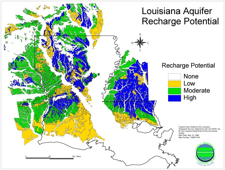
This map shows the aquifer recharge potential across the state of Louisiana only – it does NOT depict the individual aquifers. For that level of detail please order the Recharge Potential Map above.
